 25°C
25°C

How Far Can Large Ships Travel Up Dominican Rivers?
Large vessels can reach only the short, dredged stretches of the Ozama, Haina, La Romana and Higuamo rivers that serve the country's ports. Navy officials and hydrologists say geography, sediment and cost make inland navigation unrealistic for the Dominican Republic.


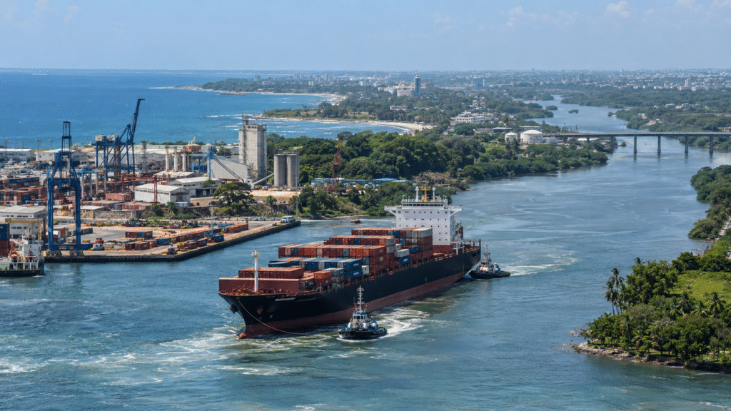
Seen from the Caribbean Sea, a river mouth can look like a gateway into the interior of the Dominican Republic. For a large ship, that gateway closes within a few kilometers. Past the port docks, the water gets shallower, sediment builds up and the channel can no longer handle deep-draft vessels.
Only four rivers can take large ships, and only near the sea: the Ozama, home to the Port of Santo Domingo in the capital; the Haina, just west of the city; the La Romana River on the southeastern coast; and the Higuamo in San Pedro de Macorís. The deepest water is in the port areas, which are kept open by regular dredging. Everywhere else, Dominican rivers can carry only small boats.
Draft, Not Tonnage, Sets the Limit
Whether a ship can enter a river depends on its draft, meaning how deep the hull sits below the waterline. The more cargo a vessel carries, the deeper it sits and the more water it needs under it. The safe draft also depends on the type of ship, not just its size.
“For a vessel to navigate safely, there must be enough depth not only for its draft, but also to maintain a safety margin under the keel, which is the lowest structural part of the hull,” said Andrés Fernández, commercial director of the La Romana Cruise Port and La Romana International Airport. Currents, tides near the coast, the shape and stability of the channel, and state regulations also affect where a ship can go.
All of this information goes into the nautical chart produced by the Dominican Navy. “Everything that is recorded and removed in this country’s waters must be entered in that document,” said Navy Captain Plinio Ramírez, director of the naval command of the Port Captaincy and Maritime Authority, and Commander Primitivo López, head of the Navy’s hydrography service. The chart tells authorities whether a given ship can operate in Dominican waters.
The Ozama: Longest Reach, Growing Obstacles
The Ozama runs 148 kilometers and has about 60 kilometers that different types of boats can use, more than any other river in the country. The Port of Santo Domingo has an estimated depth of nine to ten meters. That is deep enough for car carriers, container ships, bulk carriers, fuel tankers and tugboats.
The largest ships can sail from the Don Diego port terminal to the Riviera del Ozama neighborhood. Vessels with a draft of five to six meters can carefully continue upstream to the area around Avenida Venezuela, near Calle Francisco Segura Sandoval in the Los Mina Sur district. The river’s Floating Bridge sometimes opens to let smaller boats through. “From there on, you will never see a ship,” Ramírez said.
Sediment, the effects of climate change and trash from riverside communities keep reducing the Ozama’s depth. There is another hazard as well: about nine sunken boats sit on the riverbed. According to Ramírez, they were abandoned and carry no flag showing where they came from.
There are two ways to deal with the wrecks: move them somewhere they will not block traffic, or cut them up for scrap. Both take a lot of work and money. Even so, the Navy officers said removing them would be worth it. It would make the river navigable and would make room for docks where boats could shelter during hurricanes.
Haina: Deeper Entrance, Constant Dredging
The Haina River runs about 86 kilometers to the Caribbean, where the Port of Haina, one of the country’s main cargo hubs, sits at its mouth. Its entrance is deeper than Santo Domingo’s and can take ships with a draft of more than 13.5 meters. But that depth only covers the main entrance area. “They cannot go any further because they would hit the riverbed,” the officers said.
Past the marina, the river is no more than about four meters deep, and shallower in places. The Haina carries so much sediment that it has to be dredged constantly, with less than five months between jobs. In January 2026, authorities ordered urgent environmental work on the river after studies found it was in severe decline.
Eastern Rivers and Smaller Boats
On the eastern coast, the La Romana River has a minimum depth of 8.5 meters in its navigable channel, which lets it receive both cargo ships and cruise ships. The Higuamo in San Pedro de Macorís serves cargo ships and bulk carriers. Ramírez noted that neither river can be navigated along its full length. Ships could reach farther upstream only if the rivers were dredged.
Boca de Yuma, the Chavón River and the Cumayasa River can only take smaller boats such as yachts, sailboats and catamarans. “These rivers are dynamic,” López said, explaining that their depth changes after major weather events. Readers can find details on the country’s commercial terminals in the Dominican Port Authority’s port directory.
Geography Works Against Inland Shipping
Rivers can stop being navigable over time as nature and people change their depth, width, course and sediment. In the Dominican Republic, illegal extraction of sand and gravel, pollution and recovery projects that were started and then stalled have all made the damage worse, even after investments worth millions.
Hydrologist Ricardo Hernández says the country’s geography is the biggest barrier, and that sending deep-draft ships upriver is technically unfeasible. Most Dominican rivers are short and start high in the mountains, especially the Cordillera Central, the Caribbean’s highest mountain range. Steep slopes and damaged watersheds leave the riverbeds uneven, so a steady navigable depth is hard to keep.
Sharp dry and rainy seasons make it harder still. “During droughts, water levels drop so much that at some points the flow disconnects and stops being continuous. There is not enough depth for large vessels and there is a high risk of running aground,” Hernández said. When the rivers flood, the current becomes too dangerous for boats.
Ships would also need locks to get past steep terrain and dams, and the country has none. Hernández said locks use huge amounts of water, which the state sets aside for drinking, irrigation and hydroelectric power. He added that building and maintaining a channel for large ships would cost far more than it is worth, especially when work to prevent flooding is a higher priority.
An Island With Ports to Spare
Navy officials see little reason to push inland navigation. “We are surrounded by the sea and we have safe ports,” Ramírez said, comparing the country with landlocked Bolivia, which depends on its rivers to reach the ocean. Because Dominican rivers carry so much sediment, he said, dredging them would cost more than it would return, since they would need cleaning over and over.
López agreed. Even if the rivers were connected, he said, coastal ports such as Puerto Caucedo, the deepwater terminal east of Santo Domingo, cause fewer problems than river ports. For the country’s shipping sector, that means investment will likely keep going to deepwater coastal terminals, while river ports remain limited to the few kilometers near the sea that dredging keeps open.