 25°C
25°C

Ancient Earthquakes Reveal New Risks for the Dominican Republic
Geologists have found unusually well-preserved evidence of two earthquakes larger than magnitude 7 that shook southern-central Hispaniola roughly 2,000 and 1,800 years ago, offering a rare geological record of major earthquakes in a region where the historical record is too short to capture the full history of seismic activity. The evidence, preserved as liquefaction structures in coastal sediments at Tortuguero Beach in Ocoa Bay, links ancient ground deformation to active fault systems associated with the collision of the Beata Ridge with southern-central Hispaniola and provides new information for assessing earthquake hazard in the Dominican Republic.


For centuries, earthquakes in the Dominican Republic have been documented mainly through historical accounts of damage, shaking and destruction. Those records are valuable, but they cover only a small fraction of the time over which faults have been active. A new geological study provides a much older record: physical evidence preserved in coastal sediments shows that southern-central Hispaniola experienced at least two powerful earthquakes, estimated at more than magnitude 7, roughly 2,000 and 1,800 years ago.
The study, published in Scientific Reports in July, examined an unusually well-preserved exposure at Tortuguero Beach in Ocoa Bay. Researchers identified layers of deformed sediment that they interpret as the products of repeated earthquake-induced liquefaction. Radiocarbon dating placed two major deformation episodes about 200 years apart, while probabilistic seismic-hazard modeling pointed to several active fault systems as potential sources of the shaking. The original study in Scientific Reports describes the evidence in detail.
The finding does not predict when the next major earthquake will occur. Instead, its importance lies in extending the geological record of large earthquakes far beyond the period covered by written documents and instrumental seismology. For the Dominican Republic, that matters because understanding the long-term behavior of faults is one of the foundations of modern seismic-hazard assessment.
What the Study Found at Tortuguero Beach
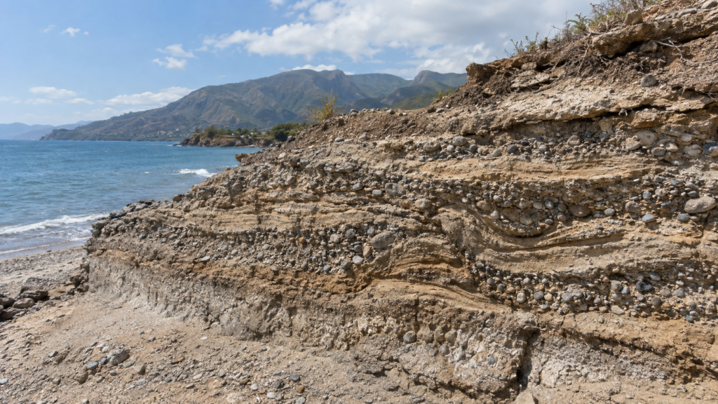
The researchers focused on a coastal exposure at Tortuguero Beach, on the southwestern side of Ocoa Bay in southern-central Hispaniola. The exposed beachrock contains a sequence of gravel, sandy gravel and coarse sand deposited in a shallow, high-energy coastal environment.
What makes the site exceptional is the way those sediments were deformed. The researchers identified a roughly 200-meter-long and 25-meter-wide exposure containing several meters of sediment with repeated deformation structures. Three distinct sedimentary sequences contain deformed layers separated by sections that remained undisturbed.
The structures include meter-scale domes and basins, evidence of fluid escape, localized lateral spreading, and local subsidence estimated at roughly 5 to 20 centimeters. Some deformation structures reach approximately 1.5 to 3 meters across. Together, these features are consistent with intense shaking that affected water-saturated sediments.
The study describes the structures as soft-sediment deformation structures, or SSDS. In this setting, they are interpreted primarily as liquefaction-related features. Rather than being simply cracks produced by an earthquake, they record a more complicated process in which strong shaking caused water pressure within the sediment to rise and temporarily weakened the material.
Why Liquefaction Leaves a Geological Record
Liquefaction occurs when strong earthquake shaking affects loose, water-saturated sediment. The shaking increases pressure within the pore spaces between sediment grains. Under the right conditions, the material can temporarily lose much of its strength and behave more like a fluid than a stable solid.
That process can force water and sediment upward, create sand or gravel boils, produce lateral spreading and deform sediment layers. If the resulting structures are subsequently buried or cemented, they can survive for thousands of years.
This makes liquefaction particularly useful to paleoseismologists, scientists who reconstruct prehistoric earthquakes from geological evidence. Historical documents may tell researchers that an earthquake damaged a town, but sedimentary structures can preserve evidence of earthquakes that occurred long before written records existed.
At Tortuguero Beach, the preservation is especially unusual because the deposits contain relatively coarse gravel and sandy gravel. The authors note that gravel-rich sediments do not normally liquefy as readily as finer sediments. Their detailed analysis of grain size, grain shape, density and permeability helped explain why liquefaction could occur in these particular layers.
How the Researchers Identified the Ancient Earthquakes
The investigation combined several independent lines of geological evidence rather than relying on a single observation. The researchers produced a high-resolution orthophoto mosaic of the exposure, carried out field mapping and sedimentary logging, analyzed the structures and sampled the rocks and sediments for laboratory testing.
Grain-size and grain-shape analyses helped the researchers understand how the sediment behaved during deformation. They found differences in permeability and density between the sand and gravel layers. Those differences could have promoted the buildup and movement of pore fluids during strong shaking.
The team also examined the geometry of the deformation. The liquefied layers contain elongated dome-and-basin structures with orientations consistent with the regional tectonic stress field. Small faults and fluid-escape structures provide additional evidence that the layers underwent significant deformation.
The researchers then turned to radiocarbon dating to establish when the deformation occurred.
How Old Were the Earthquakes?
The dating evidence came from small marine bivalve fragments preserved in the coastal sediments. The samples were analyzed using accelerator mass spectrometry and calibrated with the Marine20 marine radiocarbon calibration database. The researchers also applied a local marine-reservoir correction when converting radiocarbon measurements into calendar-age ranges.
The dating produced several overlapping age ranges. The researchers interpreted the lower deformed sequence as evidence of an earthquake approximately 2,000 years ago and the intermediate sequence as evidence of another event approximately 1,800 years ago.
The study therefore identifies two major paleo-earthquakes separated by roughly 200 years. The authors acknowledge uncertainty in the exact ages, and the approximately 200-year interval should be understood as an estimate derived from the geological record rather than as a fixed earthquake schedule.
This distinction is important. A recurrence interval does not mean that earthquakes occur according to a timetable. Geological records are incomplete, dating has uncertainties, and earthquake behavior can vary substantially from one rupture to another.
Why the Earthquakes Were Estimated at More Than Magnitude 7
The researchers did not measure the magnitudes of the ancient earthquakes directly. There was, of course, no seismometer operating in Hispaniola 2,000 years ago. Instead, they inferred earthquake size from the characteristics of the geological deformation and compared those features with established relationships between earthquake shaking and liquefaction.
The size and distribution of the liquefaction structures, together with the estimated shaking intensity, indicate that the earthquakes responsible were large. The study concludes that the events were likely Mw greater than 7, where Mw means moment magnitude, the modern magnitude scale commonly used to characterize the size of large earthquakes.
The authors also used the Environmental Seismic Intensity scale, which evaluates earthquake effects on the natural environment. The deformation observed at Tortuguero is compatible with environmental seismic intensities in the VIII to X range.
These estimates are not equivalent to an instrumental magnitude reading. They are geological reconstructions based on the physical effects left behind by the earthquakes. That distinction is central to understanding what the study establishes and what it does not.
Which Faults Could Have Produced the Shaking?
The study places the Tortuguero evidence within a complex tectonic setting. Hispaniola lies along the boundary between the Caribbean and North American plates, where plate motion is accommodated by several active fault systems rather than by one simple fault line.
In southern-central Hispaniola, the Beata Ridge is colliding with the island. The researchers identify the Beata Ridge Fault Zone and the Ocoa-Bonao-La Guacara Fault Zone as structures that accommodate deformation associated with that collision. The broader tectonic framework also includes the Muertos Trough and other active fault systems.
The study’s probabilistic seismic-hazard analysis identified the Beata Ridge Fault Zone, the Muertos Trough and, to a lesser extent, the Ocoa-Bonao-La Guacara Fault Zone as sources capable of producing ground shaking at Tortuguero consistent with the observed liquefaction.
Importantly, the researchers do not claim that one specific fault has been definitively identified as the source of each ancient earthquake. Their modeling evaluates which known seismic sources could plausibly generate the observed shaking. That is different from proving which fault actually ruptured during an individual prehistoric event.
The Connection With the 1751 Azua Earthquake
The geological findings also provide context for one of the Dominican Republic’s most important historical earthquakes: the October 18, 1751, Azua earthquake, estimated in the study at Mw 7.5.
The exact source of the 1751 earthquake remains uncertain. Historical earthquake locations in Hispaniola are often reconstructed from descriptions of damage and the intensity of shaking because instrumental measurements and direct observations of fault rupture were unavailable.
The study’s hazard modeling supports the possibility that either the Beata Ridge Fault Zone or the Muertos Trough was involved in the 1751 event. The authors therefore connect the geological evidence at Tortuguero with a broader question that has long complicated seismic-hazard research in the Dominican Republic: which active faults are responsible for the large earthquakes documented in the historical record?
The connection remains a hypothesis rather than a definitive identification of the 1751 rupture. The study itself notes that linking historical earthquakes to individual faults is difficult because surface ruptures have not been documented for many of the major historical events in southern Hispaniola.
What the Hazard Model Adds to the Geological Evidence
One of the study’s important features is that it does not stop at describing the ancient sediment deformation. The researchers also conducted a probabilistic seismic-hazard analysis, or PSHA, to examine the expected distribution of earthquake ground motion in southern-central Hispaniola.
PSHA is a framework for estimating the probability that ground shaking will exceed a specified level at a location over a defined period. It combines information about earthquake sources, possible magnitudes, occurrence rates and how seismic waves weaken with distance.
For this study, the researchers modeled peak ground acceleration, or PGA, for a 475-year return period corresponding to a 10% probability of exceedance in 50 years. The analysis incorporated different types of seismic sources, including strike-slip and reverse faults, as well as areas with lower background seismicity.
The model produced a particularly elevated hazard zone around Ocoa Bay. At Tortuguero Beach, the modeled PGA reached approximately 798 centimeters per second squared. The authors argue that this level of predicted shaking is consistent with the formation of the liquefaction structures observed at the site.
The agreement between the modeled hazard and the geological evidence is significant because it provides two different ways of evaluating the same seismic environment. The model predicts where strong shaking is plausible based on the known tectonic framework, while the sediment provides physical evidence that strong shaking actually occurred in the past.
Why the Geological Record Matters for the Dominican Republic
The Dominican Republic has a long history of damaging earthquakes, but the written record covers only a relatively short portion of geological time. The researchers note that the historical seismic record for south-central Hispaniola spans roughly the past 525 years.
That limitation can create a distorted picture of earthquake frequency. A fault may remain quiet for centuries in the historical record even though it has produced major earthquakes repeatedly over much longer geological periods.
Paleoseismology helps address that problem by extending the record beyond written history. Sedimentary layers, fault offsets, liquefaction structures and other geological features can preserve evidence of earthquakes that occurred hundreds or thousands of years ago.
Earlier research has already established that other parts of the Dominican Republic contain geological evidence of major prehistoric earthquakes. Studies of the Septentrional Fault, which runs through the Cibao Valley in northern Hispaniola, have identified prehistoric ground-rupturing earthquakes and evidence of repeated liquefaction in Holocene sediments.
The U.S. Geological Survey has described the Septentrional Fault as a major North American-Caribbean plate-boundary fault and a potential source of large earthquakes affecting the densely populated Cibao Valley. Separate research has identified generations of liquefaction features in the Cibao Valley associated with prehistoric earthquakes.
These findings show that the seismic history of the Dominican Republic is not confined to the earthquakes described in historical documents. Different geological studies are revealing evidence of large prehistoric events in both northern and southern parts of the country.
The Broader Fault System Behind the Risk
The country’s earthquake hazard cannot be reduced to a single fault. The Dominican Republic sits within a complicated zone where the Caribbean and North American plates interact obliquely, distributing deformation across several structures.
The Septentrional Fault is a major strike-slip system in the north. The Enriquillo-Plantain Garden fault system is another major structure associated with the plate boundary and extends through Hispaniola. In the south, the geological setting includes the Beata Ridge Fault Zone, the Muertos Trough and other structures involved in the deformation of southern-central Hispaniola.
This distributed tectonic setting helps explain why earthquake-hazard assessment is difficult. An earthquake’s location, depth, magnitude and rupture mechanism all influence how strongly different areas are shaken. Geological conditions near the surface can further amplify or modify the effects of an earthquake.
The new Tortuguero study is therefore best understood as an additional piece of evidence within a much larger scientific effort to characterize the country’s active faults and their long-term behavior.
What the Finding Does Not Mean
The most important limitation for the public is also the simplest: the study does not predict when another magnitude 7 earthquake will strike the Dominican Republic.
The approximately 200-year separation between the two prehistoric events is a geological observation, not a countdown clock. It does not mean that another earthquake of similar size is overdue, nor does it establish that another earthquake must occur after a fixed number of years.
Earthquake recurrence intervals are statistical and geological measures. Individual earthquakes do not occur with the regularity of scheduled events. A sequence containing two events separated by about 200 years is not enough to establish a precise recurrence cycle for a fault or region.
Nor does the study establish that the next major earthquake in the Dominican Republic will occur in Ocoa Bay, or that the next event will have the same magnitude or rupture the same fault. Its value is in demonstrating that large earthquakes have occurred in southern-central Hispaniola repeatedly over a much longer period than the historical record alone reveals.

Why Ocoa Bay Is Scientifically Important
Tortuguero Beach is valuable because geological evidence of earthquakes is not always preserved in such a clear form. Coastal environments are constantly modified by waves, storms, erosion, sediment deposition and human activity. Yet the Tortuguero exposure preserves multiple deformation episodes within a relatively accessible sequence.
The researchers attribute part of that preservation to rapid cementation of the beach sediments. Carbonate minerals formed cement within the sediment, creating relatively rigid horizons that could preserve deformation patterns. The resulting contrast between more and less cemented layers also affected how fluids moved through the deposit during later shaking.
The result is effectively a geological archive. Each deformed layer records an episode of strong shaking, while the undeformed material separating the episodes shows that the deformation was episodic rather than continuous.
For earthquake scientists, that distinction is crucial. A single deformed layer could potentially have several explanations. Multiple, separated deformation horizons provide stronger evidence for repeated seismic events.
How This Can Improve Seismic-Hazard Assessment
The practical importance of the research is not that it forecasts earthquakes. It is that geological observations can improve the models used to estimate where strong shaking is possible.
Hazard models depend on assumptions about the location, geometry, activity and potential magnitude of seismic sources. Those assumptions can be constrained by geological observations. Evidence of ancient earthquakes can show that a particular area has experienced strong shaking even when written records contain no corresponding event.
The Tortuguero evidence therefore helps connect long-term geological history with quantitative hazard modeling. The authors specifically argue that geological data should be incorporated into seismic-hazard assessments and regional risk-mitigation strategies.
For planners, engineers and emergency-management authorities, the distinction between hazard and prediction is essential. Hazard assessment asks what levels of earthquake shaking are plausible and how likely they are over a specified period. Prediction would require determining that an earthquake will occur at a particular place and time. The study addresses the first question, not the second.
The Role of the UASD National Seismology Center
The Dominican Republic also has an established national system for monitoring and studying earthquakes. The National Seismology Center of the Autonomous University of Santo Domingo (UASD), formerly known as the University Seismological Institute, has been responsible since 1948 for monitoring seismicity and administering the country’s seismic and accelerographic networks.
The center conducts research in seismic risk, tsunami risk, seismology and tectonics. Its work complements geological studies such as the Tortuguero investigation by providing instrumental observations of contemporary seismic activity.
Instrumental monitoring and paleoseismology answer different questions. Seismometers record earthquakes as they happen and help determine their location, depth and magnitude. Geological investigations examine the physical traces left by earthquakes that occurred before modern instruments existed.
Used together, the two approaches provide a much longer and more complete picture of seismic activity. The UASD center’s official monitoring and research resources are available through its National Seismology Center portal.
What the Study Means for Residents, Businesses and Visitors
For people living in the Dominican Republic, the study reinforces a basic fact of the country’s geography: earthquake risk is a long-term feature of the island’s tectonic setting. The new evidence does not change the location of the country’s active faults, but it strengthens the geological case that major earthquakes have occurred repeatedly in the past.
For visitors, the finding should not be interpreted as a warning that ordinary travel to the Dominican Republic is unsafe. The study is about regional seismic hazard, not an assessment of travel conditions or a prediction of an imminent earthquake.
For businesses, property owners and infrastructure planners, however, the broader lesson is more consequential. Long-lived buildings, roads, utilities and other infrastructure must be designed and managed with hazards that may unfold over decades or centuries in mind. Geological evidence can help authorities understand why those hazards should be considered even when large earthquakes are absent from the recent record.
What Scientists Still Need to Learn
The Tortuguero discovery also highlights how much remains uncertain. The researchers were able to identify strong prehistoric shaking and estimate its age and magnitude, but they could not conclusively assign each ancient earthquake to one specific fault.
That problem is common in Hispaniola. Historical earthquakes often lack identifiable surface ruptures, while some active faults are offshore or buried beneath younger sediments. As a result, connecting individual earthquakes to individual structures requires geological mapping, geophysical data, paleoseismic trenching, offshore investigations, GPS measurements and additional dating.
Future studies at other sites could reveal whether the events recorded at Tortuguero occurred only locally or form part of a broader regional sequence of earthquakes. Additional sites could also help determine whether the approximately 200-year interval observed in this exposure represents a meaningful regional pattern or simply the spacing of two preserved events at one location.
Those questions are important because a single geological exposure cannot provide a complete earthquake history for an entire region. Its greatest value comes when it can be compared with independent evidence from other locations.
Why the Discovery Matters Beyond One Beach
The central importance of the Tortuguero research is therefore broader than the discovery of two ancient earthquakes. It demonstrates how the landscape of the Dominican Republic can preserve evidence of seismic events that are invisible in historical documents.
The two earthquakes identified in the study occurred roughly 1,800 to 2,000 years ago, long before written records could document their effects. Yet their shaking left recognizable structures in coastal sediment that survived long enough to be studied by modern geologists.
That geological memory changes the way scientists can evaluate earthquake hazard. Instead of relying only on the relatively short historical and instrumental record, researchers can begin reconstructing a much longer sequence of major seismic events.
For the Dominican Republic, that is particularly important because the country’s earthquake hazard is distributed across a complex network of active faults. The new study adds southern-central Hispaniola to a growing body of evidence showing that large earthquakes have occurred repeatedly across the island over geological time.
The most useful conclusion is not that a major earthquake is imminent. The evidence does not support such a claim. The stronger conclusion is that earthquake risk must be understood over timescales far longer than human memory.
That is precisely where paleoseismology becomes valuable: it turns ancient geological deformation into evidence that can inform modern hazard assessment, helping scientists and authorities understand what the landscape has experienced before and what kinds of earthquakes the region is capable of producing.
Frequently Asked Questions
Did scientists discover two earthquakes in the Dominican Republic?
Yes. The study identified two episodes of earthquake-related liquefaction at Tortuguero Beach in southern-central Hispaniola and dated them to approximately 2,000 and 1,800 years ago. The researchers estimate that both earthquakes were larger than magnitude 7.
Where were the ancient earthquakes identified?
The evidence was found at Tortuguero Beach in Ocoa Bay, on the southern-central coast of Hispaniola. The site contains unusually well-preserved deformation structures in Holocene coastal sediments.
How did scientists know the deformation was caused by earthquakes?
The researchers identified characteristic liquefaction-related structures, including dome-and-basin forms, fluid-escape features, localized spreading and subsidence. They combined field observations with sedimentary, structural, grain-size and geochronological analyses and compared the structures with established evidence from earthquake-induced liquefaction.
How did scientists determine the age of the earthquakes?
They used radiocarbon dating on marine shell fragments preserved within the sedimentary sequences. The measurements were calibrated to calendar-age ranges using the Marine20 marine radiocarbon database and a local marine-reservoir correction.
Can the study predict the next major earthquake?
No. The study does not predict when the next earthquake will occur. The approximately 200-year interval between the two identified prehistoric events is an estimate from one geological record, not a timetable for future earthquakes.
Which faults are associated with the study?
The research identifies several possible seismic sources in southern-central Hispaniola. Its hazard modeling highlights the Beata Ridge Fault Zone, the Muertos Trough and, to a lesser extent, the Ocoa-Bonao-La Guacara Fault Zone as potential contributors to strong shaking at Tortuguero Beach.
Is the 1751 Azua earthquake connected to the study?
The researchers suggest that the Beata Ridge Fault Zone or the Muertos Trough may have generated the 1751 Mw 7.5 Azua earthquake. However, the precise source of that historical earthquake remains uncertain, so the proposed connection should be treated as a scientific interpretation rather than a definitive identification.
Why is paleoseismology important in the Dominican Republic?
Paleoseismology extends the earthquake record beyond written documents and instrumental measurements. Geological evidence can reveal major earthquakes that occurred hundreds or thousands of years ago, helping scientists improve estimates of long-term seismic hazard.
Conclusion
The Tortuguero Beach discovery provides one of the clearest geological windows yet into ancient earthquake activity in southern-central Hispaniola. By combining sedimentary evidence, radiocarbon dating, structural analysis and probabilistic hazard modeling, the researchers reconstructed evidence for two earthquakes larger than magnitude 7 separated by roughly 200 years.
The significance of the finding lies less in the idea of an impending earthquake than in what it reveals about the island’s deeper seismic history. Historical records cover only a small part of that history, while geological evidence can preserve traces of earthquakes that occurred long before written accounts existed.
For the Dominican Republic, the lesson is straightforward but important: seismic risk cannot be assessed solely by looking at the earthquakes remembered by recent generations. Active faults operate on much longer timescales. Understanding those timescales, identifying the structures capable of generating large earthquakes and incorporating geological evidence into hazard models are essential steps toward better long-term risk reduction.
The study does not tell scientists when the next major earthquake will occur. It does, however, strengthen the evidence that southern-central Hispaniola has experienced powerful earthquakes in the past and that those events belong in the scientific assessment of the Dominican Republic’s seismic hazard.