 30°C
30°C

Regional Climate Differences in the Dominican Republic
The Dominican Republic is known for its tropical climate, but weather conditions vary remarkably from one region to another. Mountain ranges, trade winds, elevation, and proximity to the Atlantic Ocean or Caribbean Sea create distinct climate zones, ranging from humid rainforests to semi-arid landscapes. Understanding these regional differences helps travelers, residents, investors, and outdoor enthusiasts choose the best destinations and plan activities throughout the year.


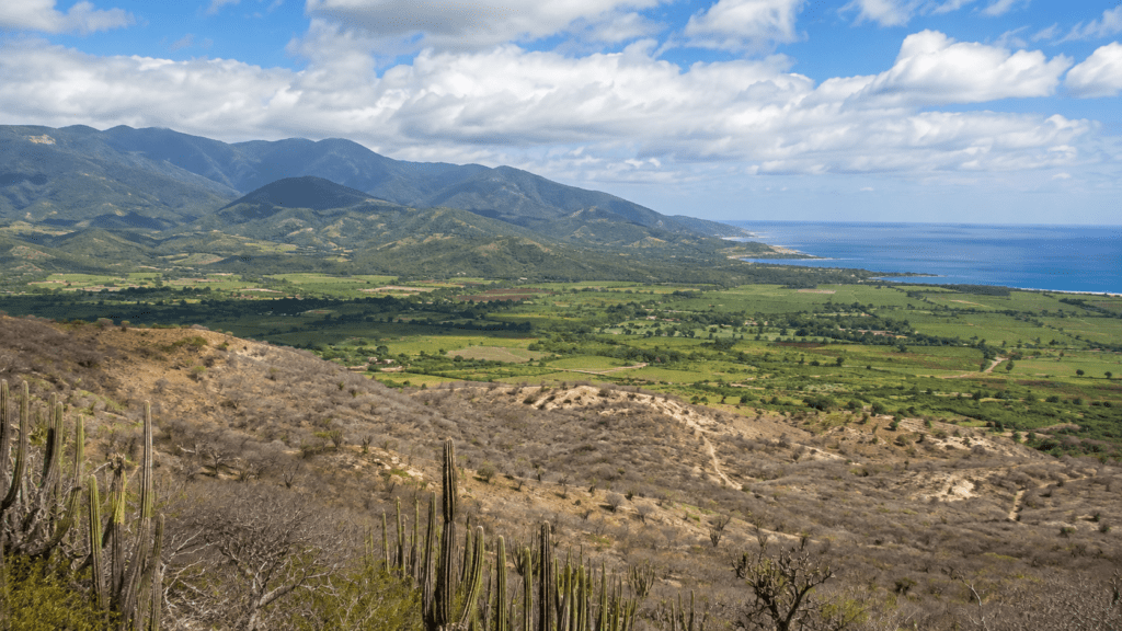
Although the Dominican Republic occupies only part of the Caribbean island of Hispaniola, it has one of the most varied climates in the region. The country’s rugged topography divides the landscape into coastal plains, fertile valleys, mountain ranges, and dry basins, producing a surprising diversity of weather patterns and ecosystems.
Rather than experiencing uniform tropical weather, each region has its own combination of temperature, rainfall, humidity, and seasonal characteristics. In many cases, locations separated by less than 100 miles (160 kilometers) experience noticeably different climates.
Why the Dominican Republic Has So Many Climate Zones
The country’s climate is shaped by several interacting geographical factors.
- Trade winds from the northeast transport moisture from the Atlantic Ocean.
- Mountain ranges force humid air upward, producing heavy rainfall on windward slopes.
- Rain shadows develop on the leeward side of mountains, creating much drier environments.
- Elevation significantly lowers temperatures in the highlands.
- Exposure to the Atlantic Ocean or Caribbean Sea influences humidity, rainfall, and seasonal weather patterns.
The Cordillera Central, Cordillera Septentrional, and other mountain systems play a particularly important role by redirecting prevailing winds and creating numerous local microclimates. These geographical features explain why the country contains humid forests, cloud forests, pine forests, fertile agricultural valleys, and semi-arid landscapes within a relatively small area.
Climate Regions Across the Country
North Coast (Puerto Plata, Cabrera, Samaná)
The Atlantic coast generally receives abundant rainfall throughout much of the year because it is directly exposed to moisture carried by the northeast trade winds. Showers are frequent, but extended periods of sunshine are also common.
Temperatures remain warm year-round, while lush vegetation and tropical forests dominate much of the landscape. Areas such as the Samaná Peninsula are among the country’s wettest regions.
Cibao Valley
Located between the Cordillera Central and the Cordillera Septentrional, the Cibao Valley benefits from fertile soils and a climate well suited for agriculture.
Rainfall varies across the valley, with eastern sections generally receiving more precipitation than the northwest. The region supports major production of rice, tobacco, cacao, and other crops.
Central Mountains
The Cordillera Central contains the highest elevations in the Caribbean, including Pico Duarte.
Higher elevations produce much cooler temperatures than coastal areas. Some mountain communities experience chilly nights throughout the year, while the highest peaks occasionally approach freezing temperatures during winter. Pine forests, cloud forests, and high-altitude ecosystems distinguish this region from the country’s tropical lowlands.
Eastern Region (Punta Cana and La Romana)
The eastern region experiences a warm tropical climate with relatively consistent temperatures throughout the year.
Rainfall is moderate and generally more evenly distributed than in other parts of the country. Sea breezes help moderate daytime heat along the coast, making the area attractive for tourism and outdoor recreation.
Southern Caribbean Coast (Santo Domingo, Baní, Barahona)
The southern coastline displays considerable climatic variation.
Santo Domingo experiences a humid tropical climate with warm temperatures year-round. Moving west toward Baní and Azua, rainfall decreases substantially because the mountains block much of the incoming Atlantic moisture.
Farther southwest, conditions become increasingly dry, with landscapes characterized by thorn scrub, cacti, and drought-resistant vegetation.
Southwest Dry Region
The provinces around Azua, Bahoruco, Independencia, and Pedernales contain some of the driest environments in the Caribbean.
Rainfall is limited because surrounding mountain ranges create a pronounced rain shadow. In places, annual precipitation is less than half that of the wetter northern regions, supporting semi-arid ecosystems that contrast sharply with the country’s tropical image.
Temperature Differences by Elevation
Altitude has a greater influence on temperature than latitude within the Dominican Republic.
| Region | Typical Climate | General Temperature Pattern |
|---|---|---|
| Coastal areas | Warm tropical | Consistently warm throughout the year |
| Interior valleys | Warm to hot | Higher daytime temperatures |
| Mountain towns | Mild | Cooler days and noticeably cooler nights |
| Highest peaks | Highland | Cold nights and occasional near-freezing winter conditions |
Average national temperatures are around 25°C (77°F), but mountain elevations can be considerably cooler than nearby coastal communities.
Rainfall Patterns
Rainfall varies more dramatically than temperature across the country.
Moisture-rich trade winds generate heavy orographic rainfall along the northern mountain slopes and in areas such as Los Haitises and the Samaná Peninsula. By contrast, regions shielded by mountain ranges—including parts of the northwest and southwest—receive much less precipitation and are more susceptible to drought. Annual rainfall in the wettest areas can exceed 3,000 millimeters, while some dry regions receive well under 1,000 millimeters.
Seasonal Weather Differences
Although temperatures change relatively little during the year, rainfall patterns follow recognizable seasonal cycles.
- November through April generally features weather influenced by frontal systems.
- May through July often brings increased convective rainfall, particularly inland.
- August through October coincides with the Atlantic hurricane season, when tropical systems may affect rainfall and weather conditions across the country.
The timing and intensity of rainfall vary considerably from one region to another depending on local geography.
How Climate Affects Daily Life
Regional climate differences influence agriculture, tourism, biodiversity, and settlement patterns throughout the Dominican Republic.
Farmers select crops according to local rainfall and elevation. Coffee and vegetables thrive in cooler mountain regions, while rice grows in irrigated valleys and cacti flourish in the southwest’s semi-arid landscapes.
For travelers, climate differences mean that beach vacations, hiking trips, whale watching, and mountain excursions each have ideal seasons depending on the destination.
Frequently Asked Questions
Which part of the Dominican Republic receives the most rain?
The northeastern region, including Los Haitises and parts of the Samaná Peninsula, is among the wettest areas due to persistent moisture carried by Atlantic trade winds and enhanced by mountainous terrain.
Which region is the driest?
The southwest, particularly around Azua, Independencia, Bahoruco, and Pedernales, has the country’s driest climate because surrounding mountains create a strong rain-shadow effect.
Does it get cold in the Dominican Republic?
Yes. While coastal areas remain warm throughout the year, high elevations in the Cordillera Central experience much cooler temperatures, especially at night and during the winter months.
Why is Punta Cana generally drier than Samaná?
Punta Cana receives less direct exposure to moisture-laden northeast trade winds than the mountainous northeastern coast, where uplift enhances rainfall.